|
THE R.A.T. PROJECT: Robotic Assistant Tourguide |
|

Robust localization algorithms for an autonomous campus tour guide
Richard Thrapp and Christian Westbrook and Devika Subramanian
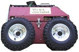
This paper describes a robust localization method for an outdoor robot that gives tours of the Rice University campus. The robot fuses odometry and GPS data using extended Kalman filtering. We propose and experimentally test a technique for handling two types of non-stationarity in GPS data quality: abrupt changes in GPS position readings caused by sudden obstructions to line of sight access to satellites, and more gradual changes caused by disparities in atmospheric conditions. We construct measurement error covariance matrices indexed by number of visible satellites and switch them into the localization computation automatically. The matrices are built by sampling GPS data repeatedly along the route and are updated continuously to handle drift in GPS data quality. We demonstrate that our approach performs better than extended Kalman filters that use only a single error covariance matrix. With a GPS receiver that delivers 1 meter accuracy, we have been able to localize good to 40 cm through a challenging route in the Engineering Quadrangle of Rice University.
Appeared in the proceedings of ICRA 2001: Powerpoint Presentation
 |
 |
|
 |
||
 |
 |